
WEST BALTIMORE MARC STATION
A new West Baltimore MARC Station is being designed as part of the Douglass/B&P Tunnel project. The community though is urging those designers to do more than the bare minimum, and be sure to include space for components that will upsize the vision of the station as an economic driver, and set in place a showpiece building that will anchor the TOD area, drive rapid residential repopulation and help knit back together the adjacent neighborhoods cleaved apart by the construction of Route 40 and the Highway to Nowhere.
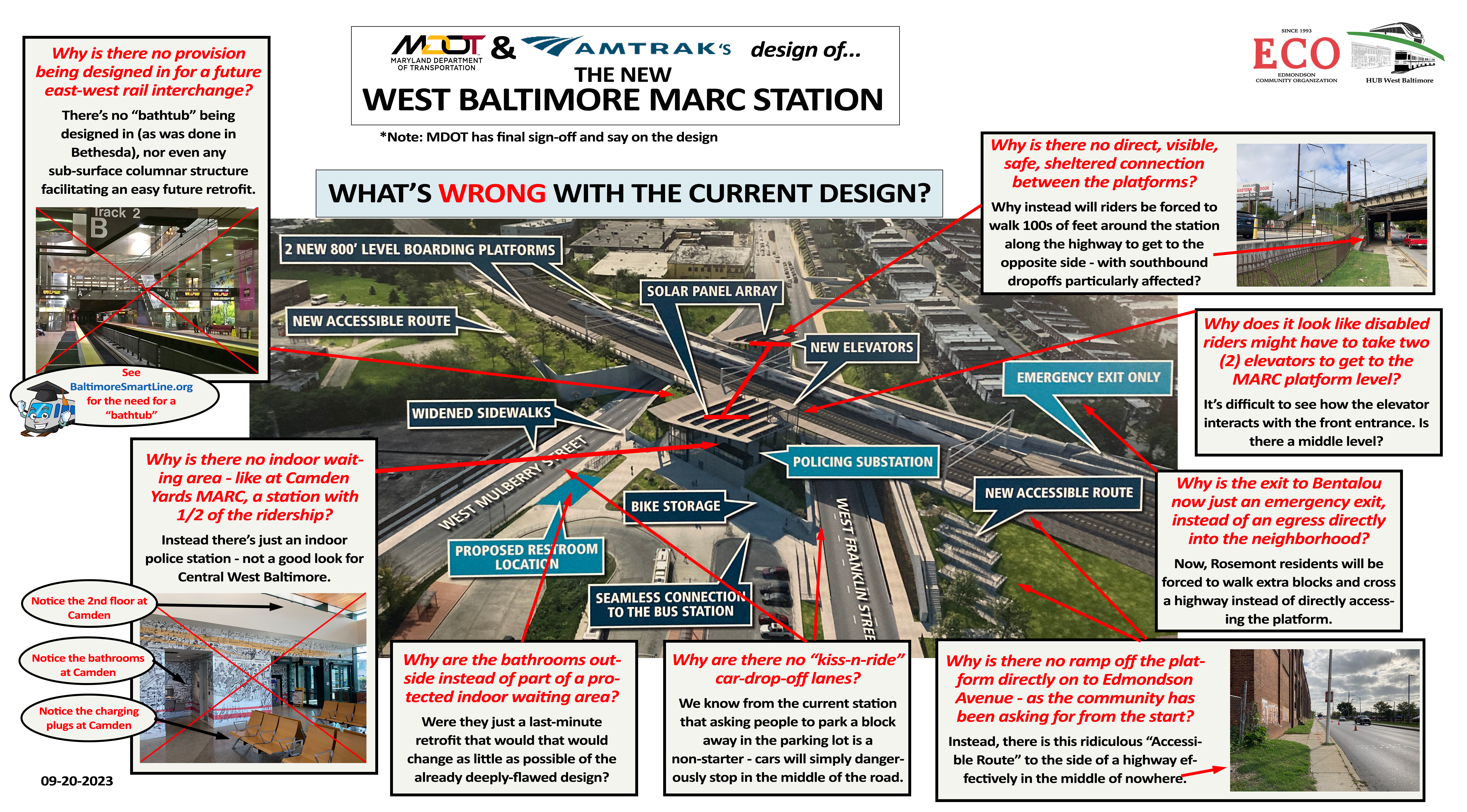
Amtrak and MDOT’s Newest West Baltimore MARC Station design, annotated with the major issues. Light blue and dark blue boxes are Amtrak/MDOT’s. The other boxes are the issues.
Redesign Critical to West Baltimore
The HUB West Baltimore MARC Station redo may be the most important project - public or private - for West Baltimore’s economy in the next two decades. At this very moment, the station is being redesigned as part of the Douglass/B&P Tunnel project. If those designers are convinced by elected and transportation leaders to think big and bold, a station could arise here that could not only catalyze massive transit-oriented development, but also help drive wholesale decades-long transformational revitalization of the surroundings neighborhoods. So there’s a massive economic imperative.
But there’s also an equity reason to think big here as well. The station is located at the center of an area that’s been ground zero for nearly a century of redlining and racially-driven disinvestment, including from policies and decisions driven by the government. So these communities are owed a huge amount of payback for that unfortunate legacy, and spending a little more here for a proper marquis, multi-modal, TOD-anchoring, neighborhood centerpiece of a station would not only be smart business, but would be a good start on the road to remedying historic imbalances.
Upgrading Costs Minimal
So what are we talking here - billions, hundreds of millions? No way.
It’s difficult to say what a design like the above would add to the cost of the currently-planned station redo, because Amtrak and State of Maryland designers haven’t released any detailed broad strokes yet on the new station and it’s exact location. But what we do know for sure is that that this 61,000 square foot building was built on the MICA campus for the super-affordable price tag of $17 million. That’s it! And it was constructed in a highly-constrained footprint with transportation corridors on two of its three major axes. So as a model for an affordable, yet transformational transportation hub, it would seem to be perfect.
To put that cost in context, Amtrak, an entity of the federal government, is spending over $5 billion of taxpayer money on this tunnel project. And the state of Maryland has already budgeted another $91 million for its share of the station cost and track work south of the station. As discussed in the Overview and Development sections, the upside for city and state budgets from even a modest revitalization of the areas around the station could rapidly eclipse that being promised by Port Covington at full build out - stretching towards a quarter of a billion dollars annually in increased revenue and savings. And the city has already given $56 million to a New York developer at the Poppleton site - with very modest returns seen so far, decades into the project. So, $20 million additional at the site would seem to be about as low-risk and high-reward as cost scoring gets. At the risk of being called hyperbolic, the city and state could potentially see the quickest full return on investment a project may have ever realized.
Geography is Key
The station lies at the western bookend of what may become in the near future Baltimore’s most high-profile public works project - the reimagining and adaptive reuse of the Highway to Nowhere.

A revitalized station would segue directly into this newly repurposed and reinvigorated spine of West Baltimore, which would then lead on the other end, directly into a massive Caves Valley redevelopment project of the old Metro West Social Security Complex - which itself lies at the western edge of the downtown. So really, this station area is nothing less than central West Baltimore’s direct connection into the center of the city - a link that would be even more reinforced with restarted construction of the Red Line light rail system.
Means of Egress Are Crucial
How do you knit together neighborhoods that were ripped apart by a highway and “urban renewal” projects? With bridges. This station sits right at the confluence of several neighborhoods, and spans the central highway scar of West Baltimore, so how it connects those neighborhoods with means of egress and transverse from the station is critical. In short, this station needs to be the central focal point of those neighborhoods, a critical shortcut across busy roads, and key conceptual connector of communities. It’s a lot to ask a single unit of piece of transportation infrastructure, but it’s quite common for train stations around the world to be asked the same - and succeed in doing it.
The latest we know about the location of the station’s platforms is the below document detailing the planned platforms. We’ve added in white a potential location for the 60,000 sq ft station, and what we believe to be key means of egress to focus on. If we end up with just two means of egress from the station, we’ve missed a tremendous opportunity.


Amtrak's proposed platform (Image 1) followed by the community's proposed amendments (Image 2) for a station building and more means of egress.